July 14, 2013, Rainier, Whitman Glacier Avalanche
7/14/13
WA Cascades West Slopes South (Mt Rainier)
72143
20
July 14, 2013, Mt Rainier, Fryingpan Glacier to Whitman Glacier: Investigating an Unusual Summertime Glacier Avalanche
NOTE: See related discussion in ), and at that time there was no evidence of anything unusual at all on that part of the Whitman Glacier. The avalanche occurred sometime between the afternoon of Sunday, June 30 (when my photos from Paradise Glacier showed no evidence of it) and July 3, when I took the photos below:

Telephoto view looking northeast from about 7400 ft on Paradise Glacier. (click for double-size version)
Telephoto view looking due east and down from Muir Rock, Point 10188. (click for double-size version)
What could have caused such an unusual event? This is definitely among the most unusual avalanches I've ever seen, probably the most unusual. I'm pretty sure I've never seen anything like it, despite spending a few hundred days skiing on and near glaciers since 1996. Looking at these photos at home later, they clearly showed an area where meltwater had reached the surface of the snowpack some distance below the terminus of the avalanche debris. Meltwater from some source, flowing under the snow (perhaps temporarily pooling atop the glacial ice?) and lubricating the icy bed surface, was apparently the most likely cause.
The period from June 30 to July 3 was the hottest of 2013 thus far in Washington, with a huge ridge of high pressure building from the desert Southwest towards the Pacific Northwest. Daily high temperatures at SeaTac Airport reached 93 °F on June 30 (the same day that Death Valley set an all-time June record high for the US of 129 °F), decreasing to 89 °F on July 1, 83 °F on July 2, and 79 °F on July 3. The freezing level at Mount Rainier was 14500 ft on June 30, increasing to 15500 ft on July 1 and 16000 ft on July 2, maxing out at 16500 ft overnight into July 3 (those are about the highest freezing levels which occur in most years on Rainier, only very rarely and barely does it exceed those values). Certainly that was ideal weather for generating a large amount of meltwater at 8000 ft on and within the Whitman Glacier.
I knew that I needed to make a trip out there to visit the site as soon as possible. But numerous other ski trips intervened (including Russell Glacier on the 4th, an Emmons-Winthrop summit ski on July 5-7, Baker via Squak on July 9, and Paradise Glacier to Muir again on July 10), followed by a couple days of inclement weather on July 11-12. By that time, access to the Whitman Glacier was not so simple anymore, given that easy access from Paradise had ended for this year (the hideously loose Cowlitz moraine at 6200 ft had entirely melted out, as had much of the southwest-facing slope above which leads to the Whitman Glacier). I decided instead to go in the other longer way, hoping to find more skiing and less loose scrambling via the Fryingpan and/or Ohanapecosh Glaciers despite the long walk needed to reach snow.
Map of the avalanche site on Whitman Glacier. (click for double-size version)
(Topo + satellite overlay map from Caltopo)
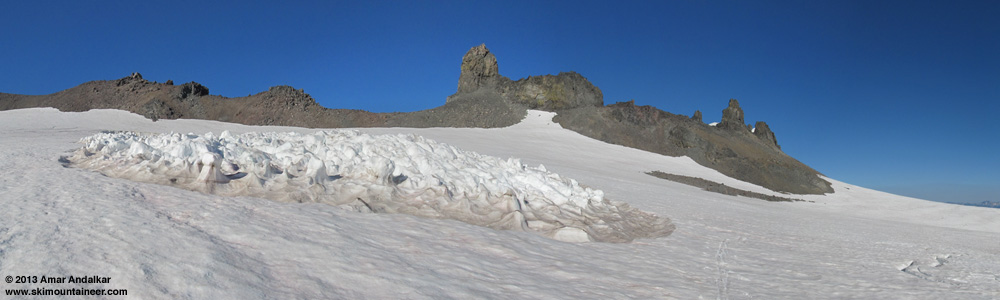
After leaving the house about 3 hours later than planned, I hiked up the Wonderland Trail from Fryingpan Creek at 11:30am and reached snow just past Summerland at about 4.5 miles and 6150 ft. Switched to skins and headed into Goat Cirque (between Meany Crest and Panhandle Gap), then up the ridge along its south side towards the eastern lobe of the Fryingpan Glacier. Unfortunately recent hot weather had melted out several areas along the ridge and its moraines, which had to be crossed on foot. I was hoping to angle southwest from near Point 7709, down into the basin and onto the Ohanapecosh Glacier near 7400 ft, then make a beeline to the 8040 ft saddle just north of the southernmost major pinnacle (8200+ ft) on Whitman Crest, which is just east of the avalanche site. I spent a fair amount of time and effort scouting a route down from the ridge, but the snowmelt nixed that plan in the end. The Ohanapecosh Glacier looked smooth and uncrevassed, almost ideal, but the descent below Point 7709 to reach it was almost entirely melted out, nothing but steep loose scree for a couple hundred feet.
Eleven-shot panorama of the entire Ohanapecosh Glacier from just below Point 7709, with Whitman Crest and the Fryingpan Glacier at right. (click for double-size version)
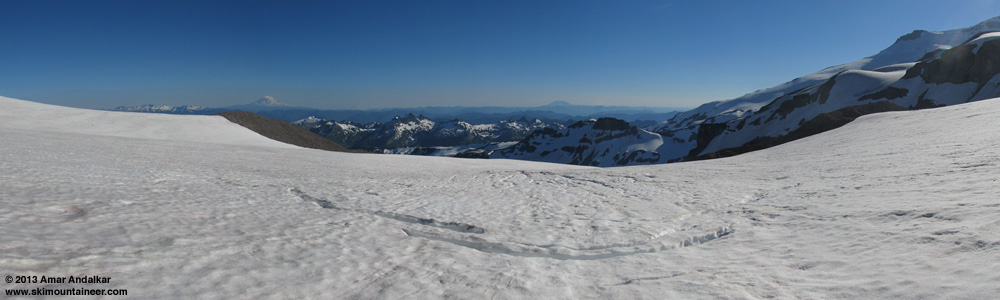
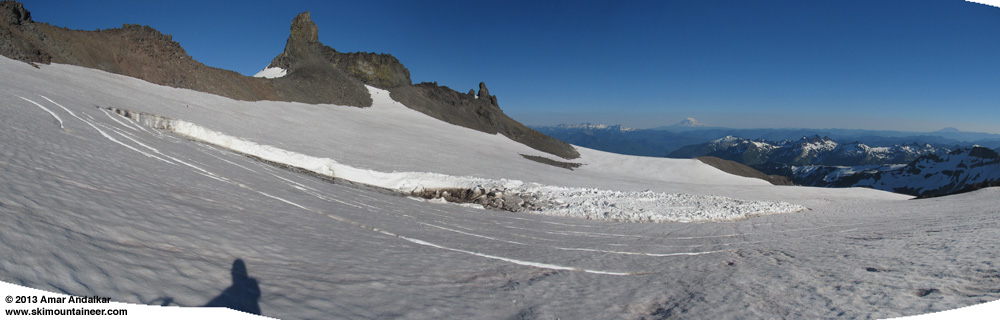
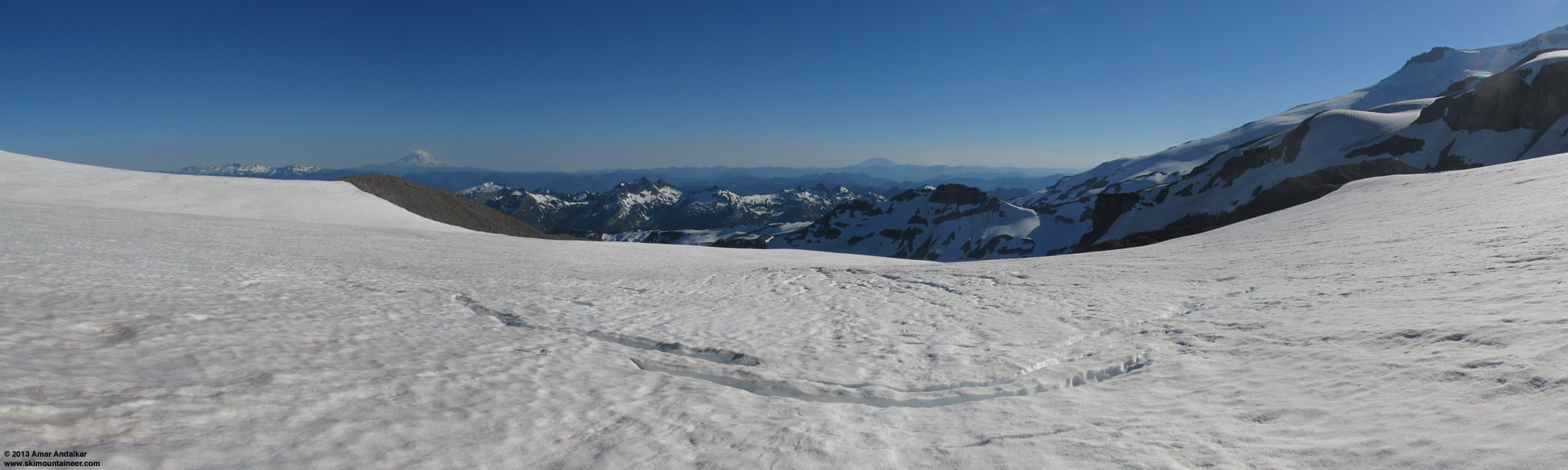
Not worth it, it would be much better to ascend the Fryingpan to Whitman Crest, and cross the saddle just north of Point 9194 to reach the Whitman Glacier. A goat path there provided a stable-enough traverse down and across to the Whitman Glacier, but the late start and Ohanapecosh scouting meant that it was 5:30pm before I was finally skiing down the glacier. Dozens of thin crevasses had opened everywhere on the Whitman during the recent hot weather, but all were only inches to a foot or so across, nothing to worry about on skis. The snow was smooth and fast with only a few old raised tracks visible, and a fast cruise quickly brought my destination into view:
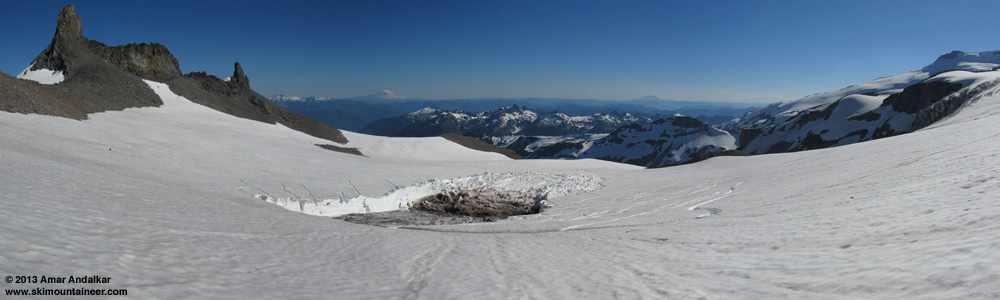
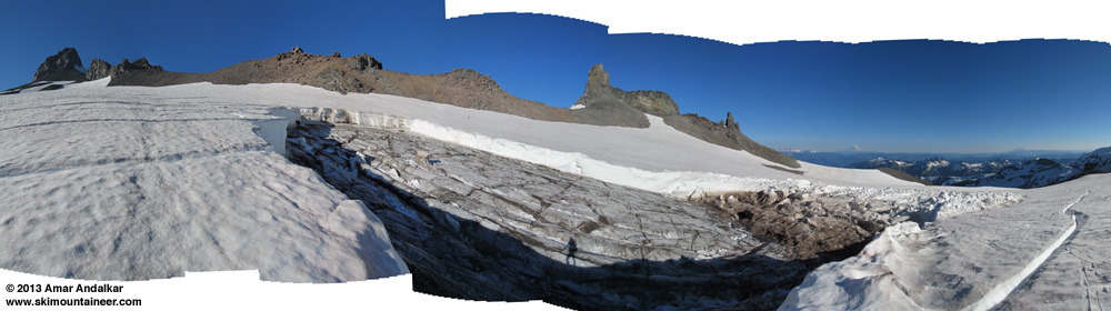
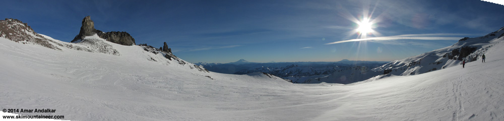
Three-shot panorama looking south of the lower Whitman Glacier and the avalanche, with Mounts Adams and Saint Helens in the distance. (click for double-size version)
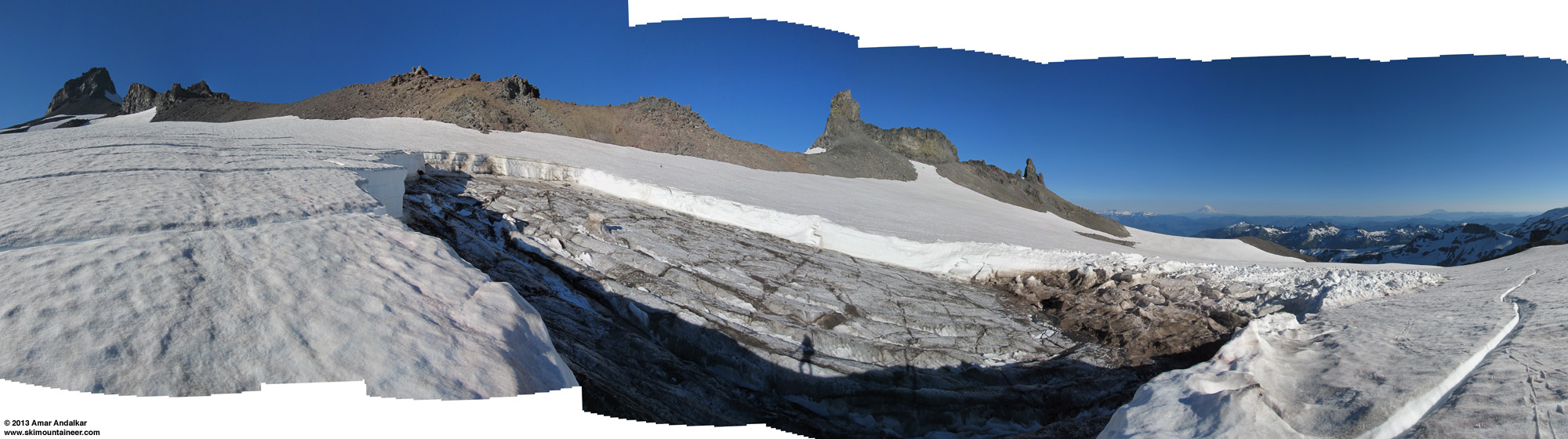
The snow surface above the avalanche crown was free of cracks, so I traversed across a safe distance above the crown.
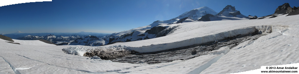
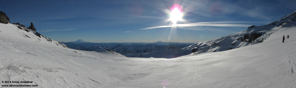
Four-shot panorama looking south from just above the avalanche site. (click for double-size version)
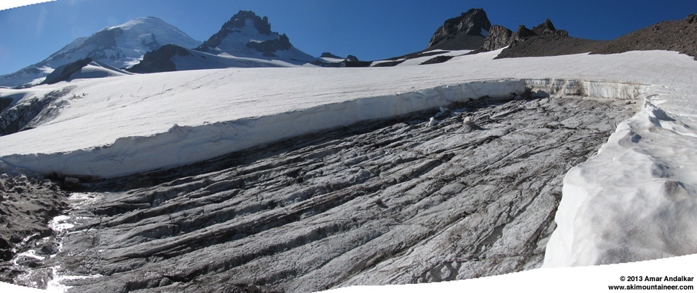
Along both sides of the avalanche path, the snowpack was fractured by numerous deep cracks, which appeared to run full-depth all the way down to the blue-ice glacial surface. Despite the cracks, everything appeared to be stable. At least 11 days had passed since the avalanche, and temperatures on this day were about 15 °F cooler than when it had occurred, so I figured it would be safe enough for some up-close exploration.
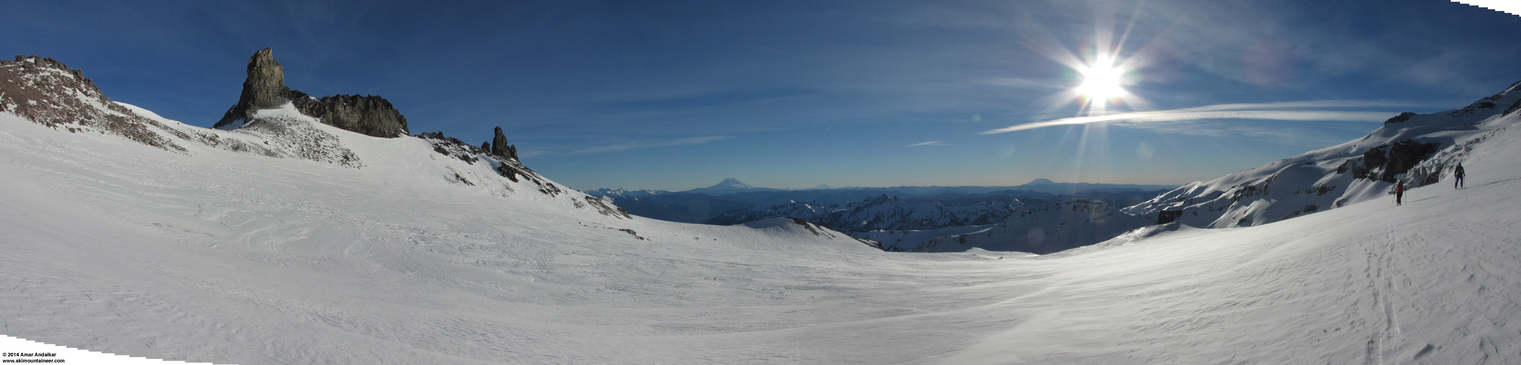
Five-shot panorama from the east side of the avalanche site. (click for double-size version)
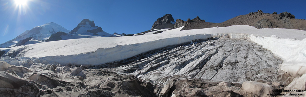
Three-shot panorama from the southeast corner of the avalanche site. (click for double-size version)
I climbed down the dirty debris near the site of the stauchwall (probing with poles repeatedly for any hidden hollows) onto the bare blue glacial ice of the bed surface. Water was actively running down numerous channels on the surface, and then disappearing down beneath the avalanche debris. I had brought crampons just in case, but the surface of the ice was quite rough and grippy, easy to walk on in ski boots with no slipping at all.
Three-shot panorama from the southeast corner of the avalanche bed surface. (click for double-size version)
I measured the height of the crown using my 120 cm ski pole, and used that height to calculate the approximate width and length of the slab from the photos. The snowpack at the crown consisted of several obvious layers. The lowermost roughly 2 ft (60 cm) was a layer of old hard firn sitting atop the glacial ice, this was clearly many years old and well on its way to becoming glacial ice. Above this was a dark dust layer and then a large layer of hard névé, almost 5 ft (1.5 m) thick. This is probably the accumulation layer from the huge 2011 snow year, which had the deepest late-summer snowpack since 1974 on Rainier. Above this another dust layer, thinner than the lower one, and then another névé layer, roughly 2.5 ft (80 cm) thick and probably from 2012's above normal accumulation. Then another thin dust layer, atop which sits 2013's remaining snowpack, roughly 1 ft (30 cm) thick, but highly variable at the crown edge due to melting since the avalanche occurred.
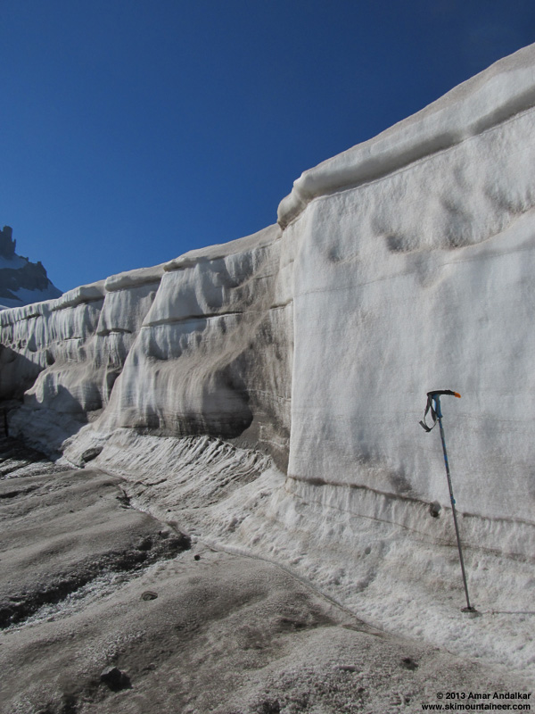
My 120 cm Whippet ski pole next to the crown, which is just over 10 ft (3 m) high at this point.
I checked the elevation of the crown and debris terminus using my GPSMAP 60CSx, which I've found to generally be accurate within a few feet (1-2 m) on summits of known elevation.
Avalanche measurements:
Crown height is about 10-11 ft (3 m), width about 90-100 ft (30 m), at almost exactly 8000 ft elevation (2440 m).
Length of slab from crown to stauchwall is about 200 ft (60 m), and slab is roughly rectangular.
Volume of slab is about 200,000 cubic ft (5400 m^3), and assuming a density of 0.6 for this old névé / firn, this implies a mass of over 3000 tons.
Path length is about 600 ft (200 m) from crown to debris terminus at 7880 ft (2400 m), for a vertical fall of about 120 ft (40 m).
Slope angle is about 15° at crown, decreasing to about 10° near debris terminus.
Slope aspect is SSW, heading roughly 195° true.
Preliminary classification:
HS-NO-R2-D3-G (hard slab - unclassified natural trigger - small relative to path - could bury a car or destroy a house - released at ground, glacial ice or firn)

Five-shot panorama looking down the avalanche bed surface from the crown. (click for double-size version)
Large meltwater channels were visible in the snowpack at the northwest corner of the avalanche site. The channels cut through the lowermost névé, and into the layer of old hard firn just above the solid glacial ice.
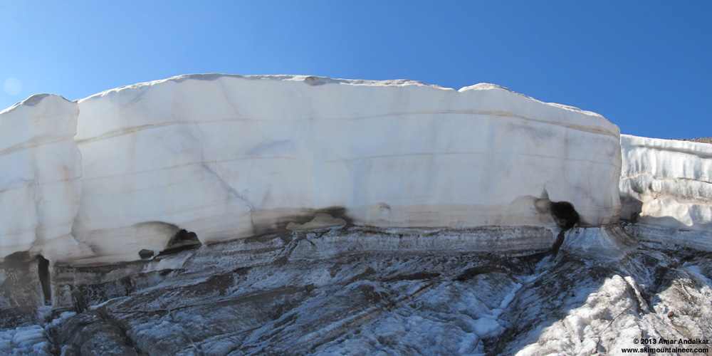
Two-shot panorama showing meltwater channels at the northwest corner of the avalanche site.
Several interesting pillars rose above the bed surface, consisting of a conical pedestal in the firn layer topped by a block of the lowermost névé. Not sure how these managed to stay in place during the movement of the avalanche, nor how much their form has changed since the avalanche due to solar effects. The highest pillar was over 5 ft (1.5 m) tall, including erosion down into the glacial ice itself, and looked quite similar in form to a
My 120 cm Whippet ski pole next to largest pillar, which is just over 5 ft (1.5 m) high.
I climbed back out of the bed surface and skied down below the terminus of the avalanche deposit. A series of cracks fractured this slope too, evidence that the meltwater had almost caused another avalanche. This is the area that appears dark and waterlogged in the July 3 photos. Perhaps the slope angle was too low here for the water-lubricated blocks of snow to start sliding downhill.
Four-shot panorama looking south from just below the terminus of the avalanche deposit. (click for double-size version)
It was time to switch to skins and head back uphill along the other (west) side of the avalanche site. Interestingly, the avalanche debris deposit also featured a number of pillars several feet high, which looked similar to those on the bed surface although formed from entirely different layers of snowpack.
Four-shot panorama looking east from just below the terminus of the avalanche deposit, with cracks visible at right. (click for double-size version)
Eight-shot vertical panorama while skinning up along the west side of the avalanche site. (click for double-size version)
By now it was after 6:30pm and I needed to start heading out, since I had about 1300 ft to ascend from here back to the saddle on Whitman Crest.
Four-shot panorama while skinning away from the avalanche site. (click for double-size version)
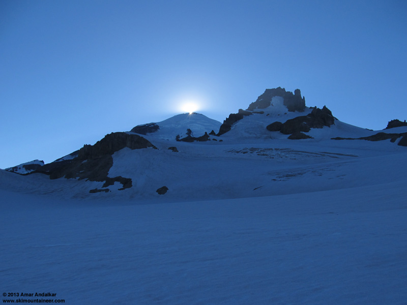
Being on the east side of the mountain, I was soon plunged into shadow just before 7pm, even though sunset was almost 2 hours away. The sun dropping down behind the crater backlit the wisps of steam rising from its rim, a memorable sight.
Cool optical effect as the sun drops behind the summit crater rim.
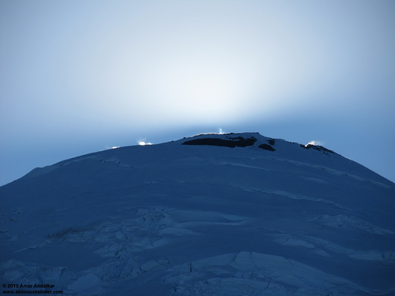
Steam rising from the summit crater rim.
With a warm day and well over 6000 ft of ascent already, I had finished all my water and didn't want to stop to fire up the Jetboil in the cold shadow. Luckily there was a mini waterfall gushing through the moraine at 8800 ft that separates a portion of the Whitman Glacier just below the Crest, so I didn't have to wait until I got down to the streams near Summerland either. I skied down the Fryingpan Glacier from Whitman Crest just before 8pm, catching a few final rays from the sun, skimming across the snow surface at grazing incidence.

Fast turns at sunset on the Fryingpan.
Still mostly smooth snow on the Fryingpan, skiing nice and fast on the refreezing corn of sunset. The direct ski lines down to the west of Meany Crest had all looked discontinuous already on the hike in, so I skied back the way I had come via the ridge of Goat Cirque. Hit the end of the snow just minutes before sunset, and then hustled back down the now-deserted Wonderland Trail, arriving a bit after 10pm.

A beautiful day exploring and investigating one of my favorite subjects, a glaciology field trip with the bonus of some very nice smooth summer skiing. About 4200 vert of turns for something over 6800 ft of gain, even not counting every little up-down as I scouted along the ridge looking for a way down to the Ohanapecosh.
[hr][tt]MOUNT RAINIER RECREATIONAL FORECAST
NATIONAL WEATHER SERVICE SEATTLE WA
357 AM PDT SUN JUL 14 2013
SYNOPSIS...DRY WEATHER WITH AVERAGE TEMPERATURES ARE ON TAP THROUGH MONDAY. TEMPERATURES WILL WARM FURTHER INTO THE 80S ON TUESDAY AS A RIDGE OF HIGH PRESSURE NUDGES TOWARD WASHINGTON AND OFFSHORE FLOW DEVELOPS. A TROUGH WILL LIKELY TRIGGER A FEW SHOWERS AND THUNDERSTORMS LATE TUESDAY AFTERNOON AND EVENING. HIGH PRESSURE WILL PROVIDE DRY WEATHER THROUGH THE REST OF THE WEEK ALONG WITH NEAR TO SLIGHTLY ABOVE AVERAGE HIGH TEMPERATURES.
SUNDAY...SUNNY. FREEZING LEVEL NEAR 12500 FEET.
SUNDAY NIGHT...CLEAR. FREEZING LEVEL NEAR 13500 FEET.
MONDAY...SUNNY. FREEZING LEVEL NEAR 13000 FEET.
MONDAY NIGHT...CLEAR. FREEZING LEVEL NEAR 14000 FEET.
TUESDAY...MOSTLY SUNNY. A CHANCE OF SHOWERS AND THUNDERSTORMS IN THE AFTERNOON. SNOW LEVEL NEAR 13000 FEET.
TEMPERATURE AND WIND FORECASTS FOR SELECTED LOCATIONS.
SUN SUN MON MON TUE
NIGHT NIGHT
SUMMIT (14411 FT) 24 25 26 26 27
W 35 W 40 SW 30 SW 40 S 35
CAMP MUIR(10188 FT) 41 41 41 46 46
W 20 W 20 S 15 SW 15 SE 15
PARADISE (5420 FT) 66 44 69 53 74
NW 5 N 10 N 5 NE 15 E 10
LONGMIRE (2700 FT) 77 47 80 48 86
CALM CALM CALM CALM CALM
++ TEMPERATURES AND WIND FOR THE SUMMIT AND CAMP MUIR ARE AVERAGE
CONDITIONS EXPECTED IN THE FREE AIR AT THOSE ELEVATIONS.
++ TEMPERATURES FOR PARADISE AND LONGMIRE ARE THE EXPECTED HIGHS AND
LOWS. WIND IS THE AVERAGE WIND EXPECTED DURING THAT PERIOD.
EXTENDED FORECAST...
TUESDAY NIGHT...MOSTLY CLOUDY WITH A CHANCE OF SHOWERS AND THUNDERSTORMS. SNOW LEVEL NEAR 13000 FEET.
WEDNESDAY...MOSTLY SUNNY. A CHANCE OF THUNDERSTORMS AND SNOW SHOWERS IN THE MORNING. SNOW LEVEL NEAR 12500 FEET.
WEDNESDAY NIGHT...PARTLY CLOUDY. FREEZING LEVEL NEAR 14000 FEET.
THURSDAY...SUNNY. FREEZING LEVEL NEAR 14000 FEET.
THURSDAY NIGHT...MOSTLY CLEAR. FREEZING LEVEL NEAR 14500 FEET.
FRIDAY...SUNNY. FREEZING LEVEL NEAR 14500 FEET.
FRIDAY NIGHT...MOSTLY CLEAR. FREEZING LEVEL NEAR 15000 FEET.
SATURDAY...SUNNY. FREEZING LEVEL NEAR 15000 FEET.
[/tt]
NOTE: See related discussion in ), and at that time there was no evidence of anything unusual at all on that part of the Whitman Glacier. The avalanche occurred sometime between the afternoon of Sunday, June 30 (when my photos from Paradise Glacier showed no evidence of it) and July 3, when I took the photos below:
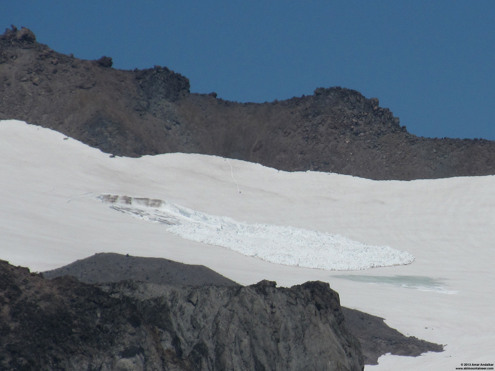
Telephoto view looking northeast from about 7400 ft on Paradise Glacier. (click for double-size version)

Telephoto view looking due east and down from Muir Rock, Point 10188. (click for double-size version)
What could have caused such an unusual event? This is definitely among the most unusual avalanches I've ever seen, probably the most unusual. I'm pretty sure I've never seen anything like it, despite spending a few hundred days skiing on and near glaciers since 1996. Looking at these photos at home later, they clearly showed an area where meltwater had reached the surface of the snowpack some distance below the terminus of the avalanche debris. Meltwater from some source, flowing under the snow (perhaps temporarily pooling atop the glacial ice?) and lubricating the icy bed surface, was apparently the most likely cause.
The period from June 30 to July 3 was the hottest of 2013 thus far in Washington, with a huge ridge of high pressure building from the desert Southwest towards the Pacific Northwest. Daily high temperatures at SeaTac Airport reached 93 °F on June 30 (the same day that Death Valley set an all-time June record high for the US of 129 °F), decreasing to 89 °F on July 1, 83 °F on July 2, and 79 °F on July 3. The freezing level at Mount Rainier was 14500 ft on June 30, increasing to 15500 ft on July 1 and 16000 ft on July 2, maxing out at 16500 ft overnight into July 3 (those are about the highest freezing levels which occur in most years on Rainier, only very rarely and barely does it exceed those values). Certainly that was ideal weather for generating a large amount of meltwater at 8000 ft on and within the Whitman Glacier.
I knew that I needed to make a trip out there to visit the site as soon as possible. But numerous other ski trips intervened (including Russell Glacier on the 4th, an Emmons-Winthrop summit ski on July 5-7, Baker via Squak on July 9, and Paradise Glacier to Muir again on July 10), followed by a couple days of inclement weather on July 11-12. By that time, access to the Whitman Glacier was not so simple anymore, given that easy access from Paradise had ended for this year (the hideously loose Cowlitz moraine at 6200 ft had entirely melted out, as had much of the southwest-facing slope above which leads to the Whitman Glacier). I decided instead to go in the other longer way, hoping to find more skiing and less loose scrambling via the Fryingpan and/or Ohanapecosh Glaciers despite the long walk needed to reach snow.

Map of the avalanche site on Whitman Glacier. (click for double-size version)
(Topo + satellite overlay map from Caltopo)
After leaving the house about 3 hours later than planned, I hiked up the Wonderland Trail from Fryingpan Creek at 11:30am and reached snow just past Summerland at about 4.5 miles and 6150 ft. Switched to skins and headed into Goat Cirque (between Meany Crest and Panhandle Gap), then up the ridge along its south side towards the eastern lobe of the Fryingpan Glacier. Unfortunately recent hot weather had melted out several areas along the ridge and its moraines, which had to be crossed on foot. I was hoping to angle southwest from near Point 7709, down into the basin and onto the Ohanapecosh Glacier near 7400 ft, then make a beeline to the 8040 ft saddle just north of the southernmost major pinnacle (8200+ ft) on Whitman Crest, which is just east of the avalanche site. I spent a fair amount of time and effort scouting a route down from the ridge, but the snowmelt nixed that plan in the end. The Ohanapecosh Glacier looked smooth and uncrevassed, almost ideal, but the descent below Point 7709 to reach it was almost entirely melted out, nothing but steep loose scree for a couple hundred feet.

Eleven-shot panorama of the entire Ohanapecosh Glacier from just below Point 7709, with Whitman Crest and the Fryingpan Glacier at right. (click for double-size version)
Not worth it, it would be much better to ascend the Fryingpan to Whitman Crest, and cross the saddle just north of Point 9194 to reach the Whitman Glacier. A goat path there provided a stable-enough traverse down and across to the Whitman Glacier, but the late start and Ohanapecosh scouting meant that it was 5:30pm before I was finally skiing down the glacier. Dozens of thin crevasses had opened everywhere on the Whitman during the recent hot weather, but all were only inches to a foot or so across, nothing to worry about on skis. The snow was smooth and fast with only a few old raised tracks visible, and a fast cruise quickly brought my destination into view:

Three-shot panorama looking south of the lower Whitman Glacier and the avalanche, with Mounts Adams and Saint Helens in the distance. (click for double-size version)
The snow surface above the avalanche crown was free of cracks, so I traversed across a safe distance above the crown.

Four-shot panorama looking south from just above the avalanche site. (click for double-size version)
Along both sides of the avalanche path, the snowpack was fractured by numerous deep cracks, which appeared to run full-depth all the way down to the blue-ice glacial surface. Despite the cracks, everything appeared to be stable. At least 11 days had passed since the avalanche, and temperatures on this day were about 15 °F cooler than when it had occurred, so I figured it would be safe enough for some up-close exploration.

Five-shot panorama from the east side of the avalanche site. (click for double-size version)

Three-shot panorama from the southeast corner of the avalanche site. (click for double-size version)
I climbed down the dirty debris near the site of the stauchwall (probing with poles repeatedly for any hidden hollows) onto the bare blue glacial ice of the bed surface. Water was actively running down numerous channels on the surface, and then disappearing down beneath the avalanche debris. I had brought crampons just in case, but the surface of the ice was quite rough and grippy, easy to walk on in ski boots with no slipping at all.

Three-shot panorama from the southeast corner of the avalanche bed surface. (click for double-size version)
I measured the height of the crown using my 120 cm ski pole, and used that height to calculate the approximate width and length of the slab from the photos. The snowpack at the crown consisted of several obvious layers. The lowermost roughly 2 ft (60 cm) was a layer of old hard firn sitting atop the glacial ice, this was clearly many years old and well on its way to becoming glacial ice. Above this was a dark dust layer and then a large layer of hard névé, almost 5 ft (1.5 m) thick. This is probably the accumulation layer from the huge 2011 snow year, which had the deepest late-summer snowpack since 1974 on Rainier. Above this another dust layer, thinner than the lower one, and then another névé layer, roughly 2.5 ft (80 cm) thick and probably from 2012's above normal accumulation. Then another thin dust layer, atop which sits 2013's remaining snowpack, roughly 1 ft (30 cm) thick, but highly variable at the crown edge due to melting since the avalanche occurred.
My 120 cm Whippet ski pole next to the crown, which is just over 10 ft (3 m) high at this point.
I checked the elevation of the crown and debris terminus using my GPSMAP 60CSx, which I've found to generally be accurate within a few feet (1-2 m) on summits of known elevation.
Avalanche measurements:
Crown height is about 10-11 ft (3 m), width about 90-100 ft (30 m), at almost exactly 8000 ft elevation (2440 m).
Length of slab from crown to stauchwall is about 200 ft (60 m), and slab is roughly rectangular.
Volume of slab is about 200,000 cubic ft (5400 m^3), and assuming a density of 0.6 for this old névé / firn, this implies a mass of over 3000 tons.
Path length is about 600 ft (200 m) from crown to debris terminus at 7880 ft (2400 m), for a vertical fall of about 120 ft (40 m).
Slope angle is about 15° at crown, decreasing to about 10° near debris terminus.
Slope aspect is SSW, heading roughly 195° true.
Preliminary classification:
HS-NO-R2-D3-G (hard slab - unclassified natural trigger - small relative to path - could bury a car or destroy a house - released at ground, glacial ice or firn)

Five-shot panorama looking down the avalanche bed surface from the crown. (click for double-size version)
Large meltwater channels were visible in the snowpack at the northwest corner of the avalanche site. The channels cut through the lowermost névé, and into the layer of old hard firn just above the solid glacial ice.
Two-shot panorama showing meltwater channels at the northwest corner of the avalanche site.
Several interesting pillars rose above the bed surface, consisting of a conical pedestal in the firn layer topped by a block of the lowermost névé. Not sure how these managed to stay in place during the movement of the avalanche, nor how much their form has changed since the avalanche due to solar effects. The highest pillar was over 5 ft (1.5 m) tall, including erosion down into the glacial ice itself, and looked quite similar in form to a
My 120 cm Whippet ski pole next to largest pillar, which is just over 5 ft (1.5 m) high.
I climbed back out of the bed surface and skied down below the terminus of the avalanche deposit. A series of cracks fractured this slope too, evidence that the meltwater had almost caused another avalanche. This is the area that appears dark and waterlogged in the July 3 photos. Perhaps the slope angle was too low here for the water-lubricated blocks of snow to start sliding downhill.
Four-shot panorama looking south from just below the terminus of the avalanche deposit. (click for double-size version)
It was time to switch to skins and head back uphill along the other (west) side of the avalanche site. Interestingly, the avalanche debris deposit also featured a number of pillars several feet high, which looked similar to those on the bed surface although formed from entirely different layers of snowpack.

Four-shot panorama looking east from just below the terminus of the avalanche deposit, with cracks visible at right. (click for double-size version)
Eight-shot vertical panorama while skinning up along the west side of the avalanche site. (click for double-size version)
By now it was after 6:30pm and I needed to start heading out, since I had about 1300 ft to ascend from here back to the saddle on Whitman Crest.

Four-shot panorama while skinning away from the avalanche site. (click for double-size version)
Being on the east side of the mountain, I was soon plunged into shadow just before 7pm, even though sunset was almost 2 hours away. The sun dropping down behind the crater backlit the wisps of steam rising from its rim, a memorable sight.
Cool optical effect as the sun drops behind the summit crater rim.
Steam rising from the summit crater rim.
With a warm day and well over 6000 ft of ascent already, I had finished all my water and didn't want to stop to fire up the Jetboil in the cold shadow. Luckily there was a mini waterfall gushing through the moraine at 8800 ft that separates a portion of the Whitman Glacier just below the Crest, so I didn't have to wait until I got down to the streams near Summerland either. I skied down the Fryingpan Glacier from Whitman Crest just before 8pm, catching a few final rays from the sun, skimming across the snow surface at grazing incidence.
Fast turns at sunset on the Fryingpan.
Still mostly smooth snow on the Fryingpan, skiing nice and fast on the refreezing corn of sunset. The direct ski lines down to the west of Meany Crest had all looked discontinuous already on the hike in, so I skied back the way I had come via the ridge of Goat Cirque. Hit the end of the snow just minutes before sunset, and then hustled back down the now-deserted Wonderland Trail, arriving a bit after 10pm.
A beautiful day exploring and investigating one of my favorite subjects, a glaciology field trip with the bonus of some very nice smooth summer skiing. About 4200 vert of turns for something over 6800 ft of gain, even not counting every little up-down as I scouted along the ridge looking for a way down to the Ohanapecosh.
[hr][tt]MOUNT RAINIER RECREATIONAL FORECAST
NATIONAL WEATHER SERVICE SEATTLE WA
357 AM PDT SUN JUL 14 2013
SYNOPSIS...DRY WEATHER WITH AVERAGE TEMPERATURES ARE ON TAP THROUGH MONDAY. TEMPERATURES WILL WARM FURTHER INTO THE 80S ON TUESDAY AS A RIDGE OF HIGH PRESSURE NUDGES TOWARD WASHINGTON AND OFFSHORE FLOW DEVELOPS. A TROUGH WILL LIKELY TRIGGER A FEW SHOWERS AND THUNDERSTORMS LATE TUESDAY AFTERNOON AND EVENING. HIGH PRESSURE WILL PROVIDE DRY WEATHER THROUGH THE REST OF THE WEEK ALONG WITH NEAR TO SLIGHTLY ABOVE AVERAGE HIGH TEMPERATURES.
SUNDAY...SUNNY. FREEZING LEVEL NEAR 12500 FEET.
SUNDAY NIGHT...CLEAR. FREEZING LEVEL NEAR 13500 FEET.
MONDAY...SUNNY. FREEZING LEVEL NEAR 13000 FEET.
MONDAY NIGHT...CLEAR. FREEZING LEVEL NEAR 14000 FEET.
TUESDAY...MOSTLY SUNNY. A CHANCE OF SHOWERS AND THUNDERSTORMS IN THE AFTERNOON. SNOW LEVEL NEAR 13000 FEET.
TEMPERATURE AND WIND FORECASTS FOR SELECTED LOCATIONS.
SUN SUN MON MON TUE
NIGHT NIGHT
SUMMIT (14411 FT) 24 25 26 26 27
W 35 W 40 SW 30 SW 40 S 35
CAMP MUIR(10188 FT) 41 41 41 46 46
W 20 W 20 S 15 SW 15 SE 15
PARADISE (5420 FT) 66 44 69 53 74
NW 5 N 10 N 5 NE 15 E 10
LONGMIRE (2700 FT) 77 47 80 48 86
CALM CALM CALM CALM CALM
++ TEMPERATURES AND WIND FOR THE SUMMIT AND CAMP MUIR ARE AVERAGE
CONDITIONS EXPECTED IN THE FREE AIR AT THOSE ELEVATIONS.
++ TEMPERATURES FOR PARADISE AND LONGMIRE ARE THE EXPECTED HIGHS AND
LOWS. WIND IS THE AVERAGE WIND EXPECTED DURING THAT PERIOD.
EXTENDED FORECAST...
TUESDAY NIGHT...MOSTLY CLOUDY WITH A CHANCE OF SHOWERS AND THUNDERSTORMS. SNOW LEVEL NEAR 13000 FEET.
WEDNESDAY...MOSTLY SUNNY. A CHANCE OF THUNDERSTORMS AND SNOW SHOWERS IN THE MORNING. SNOW LEVEL NEAR 12500 FEET.
WEDNESDAY NIGHT...PARTLY CLOUDY. FREEZING LEVEL NEAR 14000 FEET.
THURSDAY...SUNNY. FREEZING LEVEL NEAR 14000 FEET.
THURSDAY NIGHT...MOSTLY CLEAR. FREEZING LEVEL NEAR 14500 FEET.
FRIDAY...SUNNY. FREEZING LEVEL NEAR 14500 FEET.
FRIDAY NIGHT...MOSTLY CLEAR. FREEZING LEVEL NEAR 15000 FEET.
SATURDAY...SUNNY. FREEZING LEVEL NEAR 15000 FEET.
[/tt]
Wow.
Nice work, Amar.
Nice work, Amar.
great report Amar... so cool to see photos of such a unique occurrence in the mountains
Any signs of a vent coming through the underlying ice. I was reminded this past week while in Oregon and California, that we do have active volcanoes and that they often vent on quite far away from the summit. Makes me wonder if there was some hotter air coming through the ice and melted the deeper snow layer overlying the ice, causing this low angle slide.
Thanks for taking the time for this great write-up--love the scholarly combined with the tr info and pics..
Saw that phenomenon also from my Paradise Gl trip July 13. What you saw there perhaps a match to what I guessed would be from afar: a slope below typical avalanche angle and in snow much too recycled for typical avalanche mechanics. So, something else involved, probably water. Lots of it. Perhaps a mini outbreak of large quantity collecting beyond some block or dam, and then releasing to super saturate that little slide and make a big Slurpee along the glide layer where it could get thru the neve but not the ice. But ..... I've never seen anything like it, from close or far. So, wow.
Very interesting. Thanks for sharing!
We were over on the Cowlitz the same day. Heard you might be over there and looked, but we headed out too early to spot you. Thanks for the cool report and photos. I love the photos steam vent wisps.
A group of us did a trip a few years ago from Paradise to the Whitman stopping short of Little Tahoma. As we were passing, possibly nearby your photo, the glacier on which we were skinning went "thump!!!" and seemed to settle, then reverberate like we were on a drum. It did this a couple of times and even though the angle was so shallow, the time of year was late spring and we had no real fear of avalanche it was so weird that we headed for the rocks damn fast.
Glad you were able to check this thing out from nearby!
I'm reminded of something I either read or learned in my avy class, about glide avalanches preferring lower angled slopes than is typical of other snow avalanches... maybe some can confirm my foggy memory? 15 deg is apparently the minimum angle for these avalanches according to
I'm reminded of something I either read or learned in my avy class, about glide avalanches preferring lower angled slopes than is typical of other snow avalanches... maybe some can confirm my foggy memory? 15 deg is apparently the minimum angle for these avalanches according to
Since the amount of glide is a function of the amount of water at the snow/ground (or in this case glacial ice) interface, a lower angle slope should afford a greater buildup of water covering this interface and therefore a lower coefficient of friction than a higher angle slope (more pooling of water, slower draining, etc.). So yeah, I could believe that lower angle slopes above the minimum threshold would be more likely to release to glide than steeper slopes. Though at some point the impact of a trigger's weight and other forces has to come into play with the increased tension of a steeper slope...
I think the topo along with pictures 4 and 5 tell the tale of a meltwater blowout . All or most water leaving the upper whitman has to pass through this low point. Shocking that it's only 15 degrees. Now how much hydraulic force is needed to blow out or float off 3000 tons and its bonding ??
Thinking out loud - Is there a damming effect in that area ? must have been.
Thinking out loud - Is there a damming effect in that area ? must have been.
Really fascinating report. Just amazing what can actually happen. Stuff we cant predict in our wildest dreams.
Just another reminder of YOLO.
Just another reminder of YOLO.
Amar - wow and great report as usual. Melt water channels especially interesting. Bigger than I though from first couple photos.
Thanks Amar - interesting. Reminds me of low-angle rotational landslides that have occured in slow motion after rains here in areas with a clay bed - similar issue. Very odd - can't say I've seen anything similar on low angled snow before.
Okay you got this glaciologist to geek out pretty hard. That is really cool Amar.
So here goes:
water under ice (or in this case snow) is a balancing act between the immense pressure, the erosional (mechanical and thermal) force of water, and the density contrast. Plus it's on a incline, so you get many of the characteristics of confined aquifers. Pressure transponders placed in subglacial flow fluctuate wildly, but sometimes in predictable ways. At the end of a hot day, meltwater input rates are large and the channel is much smaller than the input...so the water backs up the incline imparting a greater hydraulic head. That imparts a much higher pressure in the subglacial water, which can allow it to seek out new passageways (or erode existing ones). If the hydraulic head is high enough, or if for even more complicated reasons the ice pressure is configured correctly, this can cause situations where the pressure differential exceeds the force of gravity (acting upon the ice/water density contrast) and water can FLOW UPHILL. The analogy here is and flowing artisan groundwater well caused by a confined aquifer.
I think what may have happened is that during this large heat event meltwater on the upper Whitman skyrocketed, and a lot of hydraulic head built up behind this area. Somehow, water moved into this area. Maybe the glacier was thin and the slope was right for excess water to just force its way to the surface again? But since it is not bare glacial ice, it would start just flowing at the ice/firn boundary (even more amazing is that it would fill up all ice voids above the plasticity depth first). So then you have a large (small river) sized volume of water flowing at the ice/firn boundary. Voila, instant glide avalanche.
Another potential thought exercise would be comparing this to surging glaciers.
If you haven't already, I suggest forwarding this material to Stefan Lofgren with MRNP. I believe his is in charge of glacier research on the mountain.
Thank you Amar for sharing these observations.
Fascinating. And a bit unnerving.
Coincidentally, the New York Times this morning printed this story about flood surges in the Mendenhall Glacier near Juneau.
http://www.nytimes.com/2013/07/23/us/alaska-looks-for-answers-in-glaciers-summer-flood-surges.html
Perhaps what happened is a version of what Icelanders call a jokulhlaup. Here's the Wikipedia page: http://en.wikipedia.org/wiki/J%C3%B6kulhlaup
But those seem to involve bursts of trapped subglacial water that first lift the ice and then flood out suddenly. This seems more like an avalanche facilitated by subglacial water but there doesn't seem to have a flood of water.
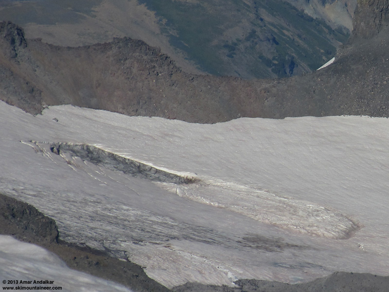
Just some late-season follow-up on this avalanche, which occurred at the start of July 2013 near 8000 ft on the Whitman Glacier.
For reference, here are a couple of photos copied from the first post above, showing the still-fresh avalanche site on July 3:
Telephoto view looking northeast from about 7400 ft on Paradise Glacier, on July 3, 2013. (click for double-size version)
Telephoto view looking due east and down from Muir Rock, Point 10188, on July 3, 2013. (click for double-size version)
Here are some views during the month of August, showing continuing ablation and substantial thinning of the snowpack surrounding the avalanche site, along with significant ablation of the bare blue glacial ice which formed the bed surface of the slide. This has dished out the bed surface into a bathtub-like form, several feet deeper across its middle than at the edge. This dishing and deepening had already begun to occur by the time I visited the avalanche site on July 14.
August 6:

Telephoto view looking ENE and across from the Paradise Glacier near 8400 ft on August 6, 2013. (click for double-size version)
Telephoto view looking ENE and down from the top of Paradise Glacier near 9000 ft on August 6, 2013. (click for double-size version)
August 18:

Telephoto view looking northeast and up from Cowlitz Rocks saddle at 7100 ft on August 18, 2013. (click for double-size version)
By mid-August, the snowpack along the edges of the avalanche site had thinned to only a couple feet thick (from 10-11 ft thick on July 14), while the depth of the bathtub appears to be at least 10 ft or more (given that the crown is about 90-100 ft wide). This implies that ablation of the bare blue glacial ice of the bed surface has been slightly greater than the surrounding snowpack, which is perhaps a surprising result. The glacial ice is denser than the surrounding firn (about 0.85-0.9 for glacial ice versus 0.55-0.6 for firn), but it is also significantly darker given its blue color and substantial amounts of dirt on its surface. Thus the absorption of sunlight by the glacial ice appears to be enough greater than the surrounding snowpack to overcome its 50% higher density, and so the glacial ice of the bed surface has ablated at a slightly faster rate during the almost 2 months of sunny dry weather since the avalanche occurred.
I had been intending to make the arduous hike up and over to the avalanche site from Summerland sometime in late September or early October, before any new snow fell, to see what it looked like after a few more months of ablation and melting following my July 14 visit. However, the unexpectedly strong storm cycle of late September this year killed that plan, with about 11" of precipitation recorded at Paradise between September 22 and October 1. The snow levels were mostly at 7000-8000 ft during the storm cycle but also dropped to under 4000 ft during the last days of September, which produced about 3 ft of new snow at Paradise by October 1 and probably 8-10 ft of new snow at the 8000 ft level, where the avalanche site is located. This was the largest September snowfall at Paradise (and the largest September storm cycle in Washington) since September 1972, so it was an extremely unusual event.
The extreme storm cycle was followed by mostly seasonable and fair weather during the first 2 weeks of October, with small amounts of additional snowfall on a couple days, and then by a huge summer-like ridge of high pressure which built during the 3rd week of the month. Given the 2 ft of solid skinnable snowpack at Paradise on October 1, the Whitman Glacier and the avalanche site could have been easily accessed on skis from Paradise during the first couple weeks of the month, and I longed to make a trip over there. However, the Teapublican Party's idiotic government shutdown strategy (strategery?) prevented access to Mount Rainier National Park during the first 16 days of October. By the time the park reopened on October 17, I was off to the East Coast to visit family for a week, so I couldn't get back up on Rainier for another look until October 23:
Telephoto view looking due east and down from Muir Rock, Point 10188, on October 23, 2013. (click for double-size version)
Obviously, the weeks of warm sunny weather since the heavy snows of late September had almost entirely melted off the snowpack below 7000 ft on the SW-facing slopes heading up from the Cowlitz Glacier to the Whitman, so access on skis from Paradise was no longer possible by October 23, and this view from Muir Rock was the best that I could get. The avalanche site is still clearly visible as a bathtub-shaped depression in the surface, despite being filled with several feet of consolidated snow, and the avalanche deposit is also faintly visible as a somewhat raised area. Interestingly, the entire snowpack at and above the crown (which was 10-11 ft deep on July 14) and also along the flanks appears to have ablated away to bare glacial ice during the subsequent 2 months of mostly warm summer weather.
Whenever a deep-enough snowpack returns to Paradise this fall, if weather permits I do hope to make another trip over to the avalanche site before it is completely buried during the winter.
For reference, here are a couple of photos copied from the first post above, showing the still-fresh avalanche site on July 3:
Telephoto view looking northeast from about 7400 ft on Paradise Glacier, on July 3, 2013. (click for double-size version)
Telephoto view looking due east and down from Muir Rock, Point 10188, on July 3, 2013. (click for double-size version)
Here are some views during the month of August, showing continuing ablation and substantial thinning of the snowpack surrounding the avalanche site, along with significant ablation of the bare blue glacial ice which formed the bed surface of the slide. This has dished out the bed surface into a bathtub-like form, several feet deeper across its middle than at the edge. This dishing and deepening had already begun to occur by the time I visited the avalanche site on July 14.
August 6:
Telephoto view looking ENE and across from the Paradise Glacier near 8400 ft on August 6, 2013. (click for double-size version)

Telephoto view looking ENE and down from the top of Paradise Glacier near 9000 ft on August 6, 2013. (click for double-size version)
August 18:
Telephoto view looking northeast and up from Cowlitz Rocks saddle at 7100 ft on August 18, 2013. (click for double-size version)
By mid-August, the snowpack along the edges of the avalanche site had thinned to only a couple feet thick (from 10-11 ft thick on July 14), while the depth of the bathtub appears to be at least 10 ft or more (given that the crown is about 90-100 ft wide). This implies that ablation of the bare blue glacial ice of the bed surface has been slightly greater than the surrounding snowpack, which is perhaps a surprising result. The glacial ice is denser than the surrounding firn (about 0.85-0.9 for glacial ice versus 0.55-0.6 for firn), but it is also significantly darker given its blue color and substantial amounts of dirt on its surface. Thus the absorption of sunlight by the glacial ice appears to be enough greater than the surrounding snowpack to overcome its 50% higher density, and so the glacial ice of the bed surface has ablated at a slightly faster rate during the almost 2 months of sunny dry weather since the avalanche occurred.
I had been intending to make the arduous hike up and over to the avalanche site from Summerland sometime in late September or early October, before any new snow fell, to see what it looked like after a few more months of ablation and melting following my July 14 visit. However, the unexpectedly strong storm cycle of late September this year killed that plan, with about 11" of precipitation recorded at Paradise between September 22 and October 1. The snow levels were mostly at 7000-8000 ft during the storm cycle but also dropped to under 4000 ft during the last days of September, which produced about 3 ft of new snow at Paradise by October 1 and probably 8-10 ft of new snow at the 8000 ft level, where the avalanche site is located. This was the largest September snowfall at Paradise (and the largest September storm cycle in Washington) since September 1972, so it was an extremely unusual event.
The extreme storm cycle was followed by mostly seasonable and fair weather during the first 2 weeks of October, with small amounts of additional snowfall on a couple days, and then by a huge summer-like ridge of high pressure which built during the 3rd week of the month. Given the 2 ft of solid skinnable snowpack at Paradise on October 1, the Whitman Glacier and the avalanche site could have been easily accessed on skis from Paradise during the first couple weeks of the month, and I longed to make a trip over there. However, the Teapublican Party's idiotic government shutdown strategy (strategery?) prevented access to Mount Rainier National Park during the first 16 days of October. By the time the park reopened on October 17, I was off to the East Coast to visit family for a week, so I couldn't get back up on Rainier for another look until October 23:
Telephoto view looking due east and down from Muir Rock, Point 10188, on October 23, 2013. (click for double-size version)
Obviously, the weeks of warm sunny weather since the heavy snows of late September had almost entirely melted off the snowpack below 7000 ft on the SW-facing slopes heading up from the Cowlitz Glacier to the Whitman, so access on skis from Paradise was no longer possible by October 23, and this view from Muir Rock was the best that I could get. The avalanche site is still clearly visible as a bathtub-shaped depression in the surface, despite being filled with several feet of consolidated snow, and the avalanche deposit is also faintly visible as a somewhat raised area. Interestingly, the entire snowpack at and above the crown (which was 10-11 ft deep on July 14) and also along the flanks appears to have ablated away to bare glacial ice during the subsequent 2 months of mostly warm summer weather.
Whenever a deep-enough snowpack returns to Paradise this fall, if weather permits I do hope to make another trip over to the avalanche site before it is completely buried during the winter.
Some more late-autumn and early-winter follow-up on this avalanche, which occurred at the start of July 2013 near 8000 ft on the Whitman Glacier.
November 28, 2013:
Due to the well-below-normal snowpack thus far this season, the avalanche site could still be discerned easily on the Whitman Glacier in late November, if you knew that you were looking for it. After skinning up to Camp Muir for some Thanksgiving corn, I hiked up to Muir Rock (Point 10188) to enjoy the stunning view looking down on Camp Muir and the Cowlitz Glacier. And also to get this zoomed view looking across at Whitman Glacier, showing the avalanche site still barely visible as a dip in the snow:
Telephoto view of Whitman Glacier avalanche site, looking due east and down from Point 10188 on November 28, 2013. (click for double-size version)
January 1, 2014:
Given the excellent forecast for New Year's Day, another trip to Camp Muir seemed to be in order. Luckily this time the winds at 10000 ft were much lighter than they had been for my previous trips on Christmas Day and December 29, 2013, almost calm this time versus randomly gusting to 40-50 mph those times, so I was able to comfortably climb up Muir Rock to get another view of the avalanche site. Since snowfall during December 2013 was far below normal, snow depth had only increased by a few feet during the previous 5 weeks even up at 8000 ft on Whitman Glacier, and the avalanche site remained just barely visible:
Telephoto view of Whitman Glacier avalanche site, looking due east and down from Point 10188 on January 1, 2014. (click for double-size version)
I also had a good view of the moraine at 6200 ft along the east edge of the Cowlitz Glacier, which appeared to finally have (barely) enough snow cover to make the ski route from Paradise to the Whitman Glacier practical. This moraine is extremely loose even by the lax standards of most moraines, and presents a significant obstacle if not well snow-covered, as it was still not on November 28, 2013:
Telephoto of the Cowlitz Glacier and its moraine, looking SE and down from Point 10188 on November 28, 2013.
Although December snowfall was far below normal, the snowdepth at Paradise nevertheless increased from 28" on November 28 to 53" on January 1 at the NWAC telemetry site, and from 23" to 54" over the same period at the park's manually-measured snow stake. That was more than enough snow to cover the Cowlitz moraine almost completely, with only the larger boulders on the surface of the moraine still exposed. Here it is looking much better, probably now skinnable without too much issue if the snow is soft or easily cramponable if icy, as of January 1, 2014:

An even more telephoto view of the Cowlitz Glacier moraine, looking SE and down from Point 10188 on January 1, 2014.
Now that the snowpack appears to be deep enough, if weather and time permits I've been intending to make another trip over to the avalanche site before it's completely buried during the winter. Although there doesn't appear to be too much left to see of the avalanche itself, it's an excellent ski tour in any case, and the weather this weekend may be perfect for heading over there.
November 28, 2013:
Due to the well-below-normal snowpack thus far this season, the avalanche site could still be discerned easily on the Whitman Glacier in late November, if you knew that you were looking for it. After skinning up to Camp Muir for some Thanksgiving corn, I hiked up to Muir Rock (Point 10188) to enjoy the stunning view looking down on Camp Muir and the Cowlitz Glacier. And also to get this zoomed view looking across at Whitman Glacier, showing the avalanche site still barely visible as a dip in the snow:
Telephoto view of Whitman Glacier avalanche site, looking due east and down from Point 10188 on November 28, 2013. (click for double-size version)
January 1, 2014:
Given the excellent forecast for New Year's Day, another trip to Camp Muir seemed to be in order. Luckily this time the winds at 10000 ft were much lighter than they had been for my previous trips on Christmas Day and December 29, 2013, almost calm this time versus randomly gusting to 40-50 mph those times, so I was able to comfortably climb up Muir Rock to get another view of the avalanche site. Since snowfall during December 2013 was far below normal, snow depth had only increased by a few feet during the previous 5 weeks even up at 8000 ft on Whitman Glacier, and the avalanche site remained just barely visible:
Telephoto view of Whitman Glacier avalanche site, looking due east and down from Point 10188 on January 1, 2014. (click for double-size version)
I also had a good view of the moraine at 6200 ft along the east edge of the Cowlitz Glacier, which appeared to finally have (barely) enough snow cover to make the ski route from Paradise to the Whitman Glacier practical. This moraine is extremely loose even by the lax standards of most moraines, and presents a significant obstacle if not well snow-covered, as it was still not on November 28, 2013:
Telephoto of the Cowlitz Glacier and its moraine, looking SE and down from Point 10188 on November 28, 2013.
Although December snowfall was far below normal, the snowdepth at Paradise nevertheless increased from 28" on November 28 to 53" on January 1 at the NWAC telemetry site, and from 23" to 54" over the same period at the park's manually-measured snow stake. That was more than enough snow to cover the Cowlitz moraine almost completely, with only the larger boulders on the surface of the moraine still exposed. Here it is looking much better, probably now skinnable without too much issue if the snow is soft or easily cramponable if icy, as of January 1, 2014:
An even more telephoto view of the Cowlitz Glacier moraine, looking SE and down from Point 10188 on January 1, 2014.
Now that the snowpack appears to be deep enough, if weather and time permits I've been intending to make another trip over to the avalanche site before it's completely buried during the winter. Although there doesn't appear to be too much left to see of the avalanche itself, it's an excellent ski tour in any case, and the weather this weekend may be perfect for heading over there.
I finally did manage to make a follow-up visit in early January 2014, just before the much-belated first major week-long winter storm cycle of the 2013-14 season arrived, bringing several more feet of snowfall at the 8000 ft elevation.
January 5, 2014:
Unfortunately, there was very little evidence left of the July avalanche, only a pronounced dip in the surface of the glacier extending across several tens of meters with a maximum depth of a few meters, and a short strip of exposed glacial ice at what was once the east flank of the avalanche bed surface. A bit disappointing for me that there was so little left to see, but roughly what I expected to find based on the January 1 telephoto view from Muir Rock.
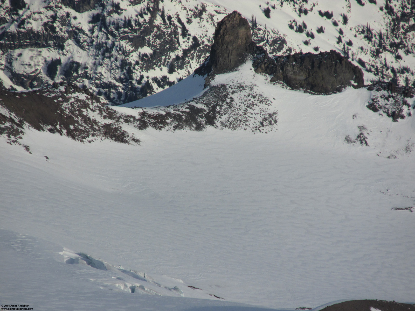
Six-shot panorama of the Whitman Glacier from the west side of the July avalanche site. (click for triple-size version)
Four-shot panorama of the Whitman Glacier from near the exposed ice (left) at the east flank of the July avalanche site.
I'm standing within the remaining depression, near the center of the bed surface of the original avalanche. (click for double-size version)
Although there won't be anything to see there for the rest of the winter and spring, I suspect that by mid-late summer this year, the seasonal snowpack at the avalanche site will have ablated away (assuming that the net snow mass balance at that location on the glacier is negative for this year, enough to expose the site once again by late summer of 2014). In that case, much evidence of the event should be visibile in the bare glacial ice, perhaps something like a large rectangular pit with roughly the dimensions of the original slab, incised several feet deep into the glacial ice, similar to the bathtub-like depression seen in the August photos above.
Full trip report:
January 5, 2014, Mount Rainier, Whitman Glacier: Visiting the July 2013 Avalanche Site + Bonus Ice Cave!
January 5, 2014:
Unfortunately, there was very little evidence left of the July avalanche, only a pronounced dip in the surface of the glacier extending across several tens of meters with a maximum depth of a few meters, and a short strip of exposed glacial ice at what was once the east flank of the avalanche bed surface. A bit disappointing for me that there was so little left to see, but roughly what I expected to find based on the January 1 telephoto view from Muir Rock.
Six-shot panorama of the Whitman Glacier from the west side of the July avalanche site. (click for triple-size version)

Four-shot panorama of the Whitman Glacier from near the exposed ice (left) at the east flank of the July avalanche site.
I'm standing within the remaining depression, near the center of the bed surface of the original avalanche. (click for double-size version)
Although there won't be anything to see there for the rest of the winter and spring, I suspect that by mid-late summer this year, the seasonal snowpack at the avalanche site will have ablated away (assuming that the net snow mass balance at that location on the glacier is negative for this year, enough to expose the site once again by late summer of 2014). In that case, much evidence of the event should be visibile in the bare glacial ice, perhaps something like a large rectangular pit with roughly the dimensions of the original slab, incised several feet deep into the glacial ice, similar to the bathtub-like depression seen in the August photos above.
Full trip report:
January 5, 2014, Mount Rainier, Whitman Glacier: Visiting the July 2013 Avalanche Site + Bonus Ice Cave!
Reply to this TR
Please login first: